Rodway Hill Bridge: Difference between revisions
Jump to navigation
Jump to search
New page: <div style="float:right"> <googlemap lat="51.477588" lon="-2.479649"> 51.476706, -2.480099, Rodway Hill Bridge </googlemap> </div> '''To Bristol''': Mangotsfield<br> '''To Yate''': [[M... |
No edit summary |
||
| Line 5: | Line 5: | ||
</div> | </div> | ||
'''To Bristol''': [[Mangotsfield]]<br> | '''To Bristol''': [[Mangotsfield]]<br> | ||
'''To Yate''': [[ | '''To Yate''': [[Sentinals I & II]] | ||
== Gallery == | == Gallery == | ||
<gallery> | <gallery> | ||
Image:Rodway Hill Bridge1.jpg| | Image:Rodway Hill Bridge1.jpg|The bridge across the trackbed at '''Rodway Hill''' is glimpsed through the trees. This is the view north. | ||
Image:Rodway Hill Bridge2.jpg| | Image:Rodway Hill Bridge2.jpg|This archway is on the right of the main bridge when viewed looking north. | ||
Image:Rodway Hill Bridge3.jpg| | Image:Rodway Hill Bridge3.jpg|The bridge viewed looking south. [[Mangotsfield]] station is just out of sight through the trees. | ||
Image:Rodway Hill Bridge4.jpg| | Image:Rodway Hill Bridge4.jpg|This arch is on the right of the main bridge when viewed looking south. | ||
</gallery> | </gallery> | ||
[[Category:Bridges]] | [[Category:Bridges]] | ||
[[Category:Bristol & Gloucestershire Railway]] | [[Category:Bristol & Gloucestershire Railway]] | ||
Revision as of 21:01, 4 January 2008
<googlemap lat="51.477588" lon="-2.479649"> 51.476706, -2.480099, Rodway Hill Bridge </googlemap>
To Bristol: Mangotsfield
To Yate: Sentinals I & II
Gallery
-
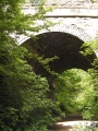
 The bridge across the trackbed at Rodway Hill is glimpsed through the trees. This is the view north.
 -
 This archway is on the right of the main bridge when viewed looking north.
 -
 The bridge viewed looking south. Mangotsfield station is just out of sight through the trees.
 -
 This arch is on the right of the main bridge when viewed looking south.


