Lockleaze Road: Difference between revisions
Jump to navigation
Jump to search
BristleGWR (talk | contribs) New page: <div style="float:right"> <googlemap lat="51.48924" lon="-2.570758" zoom="15"> 51.4893, -2.570736, Lockleaze Road </googlemap> </div> '''To Bristol or Bath''': Lockleaze Footbridge <br... |
BristleGWR (talk | contribs) No edit summary |
||
| Line 27: | Line 27: | ||
[[Category:B&SWUR]] | [[Category:B&SWUR]] | ||
[[Category:Filton Bank]] | [[Category:Filton Bank]] | ||
[[Category: | [[Category:Peter Rendall]] | ||
Revision as of 21:50, 11 January 2008
<googlemap lat="51.48924" lon="-2.570758" zoom="15"> 51.4893, -2.570736, Lockleaze Road </googlemap>
To Bristol or Bath: Lockleaze Footbridge
To Wales, The North or London: Horfield
History
1983
This photo was kindly sent to me by Peter Rendall of Past Track Publications. Peter specializes in reproducing actual-size diagrams from most of the Bristol area signalboxes. Please check out his website :)

2004
-
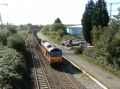 Looking south towards Lockleaze Footbridge while 60085 hauls an engineering train up the hill.
 -
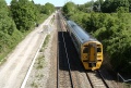 158826 trundles past the site of Horfield Station and under the bridge at Lockleaze Road.
 -
 Ah.. bliss.. 40145 coasts past on the Western Whisperer on the 22nd May 2004. Not the best pic I've ever taken... guess who nearly dropped his camera five seconds previously.. argh!
 -
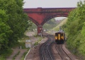 A telephoto view of the site of Horfield Station with 150233 passing the remains of one of the platforms.


2005
-
 A December 2005 look at the bridge itself. It is due to be transformed in 2006 as part of a Feeling Good, Feeling Safe Group's community project.
