Lockleaze Road: Difference between revisions
Jump to navigation
Jump to search
| Line 11: | Line 11: | ||
<gallery> | <gallery> | ||
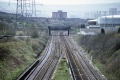
Image:Lockleaze Road1.jpg|The view from the bridge with the remains of [[Horfield]] station visible in the distance. ''© [[:Category:Peter Rendall|P.D.Rendall]]'' | Image:Lockleaze Road1.jpg|The view from the bridge with the remains of [[Horfield]] station visible in the distance. ''© [[:Category:Peter Rendall|P.D.Rendall]]'' | ||
Image:Lockleaze Road7.jpg|The view of '''Lockleaze Road''' from [[Bonnington | Image:Lockleaze Road7.jpg|The view of '''Lockleaze Road''' from [[Bonnington Walk]] bridge. ''© [[:Category:Peter Rendall|P.D.Rendall]]'' | ||
</gallery> | </gallery> | ||
Revision as of 17:20, 12 January 2008
<googlemap lat="51.48924" lon="-2.570758"> 51.4893, -2.570736, Lockleaze Road </googlemap>
To Bristol or Bath: Lockleaze Footbridge
To Wales, The North or London: Horfield
History
1983
-
The view from the bridge with the remains of Horfield station visible in the distance. © P.D.RendallThe view from the bridge with the remains of Horfield station visible in the distance. © P.D.Rendall
-
 The view of Lockleaze Road from Bonnington Walk bridge. © P.D.Rendall

2004
-
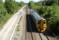
 Looking south towards Lockleaze Footbridge while 60085 hauls an engineering train up the hill.
 -
-
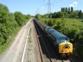 Ah.. bliss.. 40145 coasts past on the Western Whisperer on the 22nd May 2004. Not the best photo I've ever taken... guess who nearly dropped his camera five seconds previously..
 -


2005
-
A December 2005 look at the bridge itself. It is due to be transformed in 2006 as part of a Feeling Good, Feeling Safe Group's community project.
Videos
- 66057 hauls a coal train 25.10.06
- 47839 and 47805 hurtle down the hill 26.3.07
- 6024 on the Red Dragon 22.4.07
- 6024 on the Red Dragon 22.4.07
- 6201 Princess Elizabeth climbs Filton Bank 10.11.07