Temple Meads: Difference between revisions
Jump to navigation
Jump to search
New page: <div style="float:right"> <googlemap lat="51.450263" lon="-2.57947"> 51.449059, -2.580199, Temple Meads </googlemap> </div> '''To the Southwest''': Cattle Market Road<br> '''To Wales, ... |
No edit summary |
||
| Line 6: | Line 6: | ||
'''To the Southwest''': [[Cattle Market Road]]<br> | '''To the Southwest''': [[Cattle Market Road]]<br> | ||
'''To Wales, the North or Bath''': [[River Avon]] | '''To Wales, the North or Bath''': [[River Avon]] | ||
== History == | |||
== 1900s == | |||
<gallery> | |||
Image:Temple Meads1.jpg|A view of the south end of the station taken circa 1911. | |||
</gallery> | |||
== 1940s == | |||
<gallery> | |||
Image:Temple Meads2.jpg|An early view of Temple Meads taken from an old postcard. It shows horse drawn taxis and a Cabmans shelter. The spire on the clock tower was destroyed by a German incendiary bomb in an air raid on 3 January [[1941]]. | |||
</gallery> | |||
== 1950s == | |||
<gallery> | |||
Image:Temple Meads3.jpg|[[w:GWR 4073 Class|Castle]] class '''5069''' Isambard Kingdom Brunel at the east end of TM. This loco was built in 1938. All Castles had smokebox number plates fitted by January 1951 so this photo was taken before that date. ''© [[:Category:Michelle Howe|Michelle Howe]] | |||
</gallery> | |||
== 1960s == | |||
<gallery> | |||
Image:Temple Meads1.jpg| | |||
</gallery> | |||
== 1970s == | |||
<gallery> | |||
Image:Temple Meads1.jpg| | |||
</gallery> | |||
== 1980s == | |||
<gallery> | |||
Image:Temple Meads1.jpg| | |||
</gallery> | |||
== 1990s == | |||
<gallery> | |||
Image:Temple Meads1.jpg| | |||
</gallery> | |||
== Gallery == | |||
<gallery> | |||
Image:Temple Meads1.jpg| | |||
</gallery> | |||
== Gallery == | == Gallery == | ||
<gallery> | <gallery> | ||
Image:Temple Meads1.jpg| | Image:Temple Meads1.jpg| | ||
</gallery> | </gallery> | ||
[[B&ER]] | |||
[[Category:GWR]] | [[Category:GWR]] | ||
[[Category:Michelle Howe]] | |||
[[Category:Stations]] | [[Category:Stations]] | ||
[[Category:Temple Meads]] | |||
Revision as of 10:01, 14 January 2008
<googlemap lat="51.450263" lon="-2.57947"> 51.449059, -2.580199, Temple Meads </googlemap>
To the Southwest: Cattle Market Road
To Wales, the North or Bath: River Avon
History
1900s
-
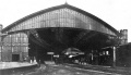 A view of the south end of the station taken circa 1911.

1940s
-
 An early view of Temple Meads taken from an old postcard. It shows horse drawn taxis and a Cabmans shelter. The spire on the clock tower was destroyed by a German incendiary bomb in an air raid on 3 January 1941.

1950s
-
 Castle class 5069 Isambard Kingdom Brunel at the east end of TM. This loco was built in 1938. All Castles had smokebox number plates fitted by January 1951 so this photo was taken before that date. © Michelle Howe
