Avon Crescent Level Crossing: Difference between revisions
Jump to navigation
Jump to search
New page: <div style="float:right"> <googlemap lat="51.449193" lon="-2.618437"> 51.446946, -2.618963, Avon Crescent Level Crossing </googlemap> </div> '''To Canons Marsh''': [[Avon Crescent Signal B... |
No edit summary |
||
| Line 7: | Line 7: | ||
'''To Ashton Junction''': [[Cumberland Road West]] | '''To Ashton Junction''': [[Cumberland Road West]] | ||
== History == | == History == | ||
This was also the location of a pedestrian footbridge across the railway. | |||
== Gallery == | == Gallery == | ||
<gallery> | <gallery> | ||
Image:Avon Crescent Level Crossing1.jpg| | Image:Avon Crescent Level Crossing1.jpg|The view from Avon Crescent towards [[Cumberland Road West]]. A boatyard stands on the alignment of the railway. | ||
Image:Avon Crescent Level Crossing2.jpg|The two stone pillars on the right of this photo show where the railway crossed the road. | |||
Image:Avon Crescent Level Crossing3.jpg|The railway used to run behind the Novia Scotia pub before crossing locks at the entrance to Bristol. The alignment is now housing and garages. | |||
</gallery> | </gallery> | ||
[[Category:GWR]] | [[Category:GWR]] | ||
[[Category:Level Crossings]] | [[Category:Level Crossings]] | ||
Revision as of 11:21, 25 January 2008
<googlemap lat="51.449193" lon="-2.618437"> 51.446946, -2.618963, Avon Crescent Level Crossing </googlemap>
To Canons Marsh: Avon Crescent Signal Box
To Ashton Junction: Cumberland Road West
History
This was also the location of a pedestrian footbridge across the railway.
Gallery
-
 The view from Avon Crescent towards Cumberland Road West. A boatyard stands on the alignment of the railway.
 -
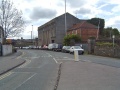 The two stone pillars on the right of this photo show where the railway crossed the road.
 -
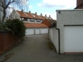 The railway used to run behind the Novia Scotia pub before crossing locks at the entrance to Bristol. The alignment is now housing and garages.


