The Portway: Difference between revisions
Jump to navigation
Jump to search
No edit summary |
No edit summary |
||
| Line 10: | Line 10: | ||
== Gallery == | == Gallery == | ||
<gallery> | <gallery> | ||
Image:Portway4.jpg|The bridge viewed from [[Sea Mills]] station. | |||
Image:Portway1.jpg|The view across the bridge and looking towards Bristol. | Image:Portway1.jpg|The view across the bridge and looking towards Bristol. | ||
Image:Portway2.jpg|The view into Bristol with the tree-lined Avon Gorge in the distance. This was once the location of [[Sneyd Park Junction]] and the line to [[Hotwells]]. [[Bramble Lane|The bridge]] visible carries a footpath from the Portway to Old Sneed Park. | Image:Portway2.jpg|The view into Bristol with the tree-lined Avon Gorge in the distance. This was once the location of [[Sneyd Park Junction]] and the line to [[Hotwells]]. [[Bramble Lane|The bridge]] visible carries a footpath from the Portway to Old Sneed Park. | ||
Revision as of 15:45, 26 January 2008
<googlemap lat="51.476893" lon="-2.647705"> 51.477013, -2.648606, The Portway </googlemap>
To Bristol: Sneyd Park Junction
To Avonmouth: Sea Mills
History
The Portway is the name for the A4 road as it travels through the Avon Gorge (and under the Clifton Suspension Bridge) into Bristol. As the road enters Bristol it was built partly on the alignment of the Bristol Port Railway & Pier's Hotwells branch.
Gallery
-
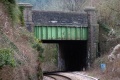 The bridge viewed from Sea Mills station.
 -
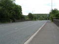 The view across the bridge and looking towards Bristol.
 -
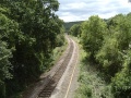 The view into Bristol with the tree-lined Avon Gorge in the distance. This was once the location of Sneyd Park Junction and the line to Hotwells. The bridge visible carries a footpath from the Portway to Old Sneed Park.
 -
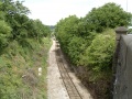 The view north with Sea Mills station visible in the distance.


