Clifton Down: Difference between revisions
Jump to navigation
Jump to search
No edit summary |
No edit summary |
||
| Line 7: | Line 7: | ||
'''To Avonmouth''': [[St Johns Road]] | '''To Avonmouth''': [[St Johns Road]] | ||
== History == | == History == | ||
== Track Plans == | |||
<gallery> | |||
Image:Clifton Down Track Plan 1988.jpg|A track plan of Clifton Down and surrounding area from 1988. | |||
</gallery> | |||
== Gallery == | == Gallery == | ||
<gallery> | <gallery> | ||
Revision as of 18:30, 4 February 2008
<googlemap lat="51.466039" lon="-2.610025"> 51.464502, -2.610841, Clifton Down </googlemap>
To Bristol: Whiteladies Road
To Avonmouth: St Johns Road
History
Track Plans
-
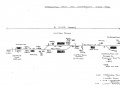 A track plan of Clifton Down and surrounding area from 1988.

Gallery
-
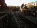
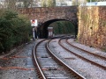
 Standing in the tunnel under Whiteladies Road looking towards Redland.
 -
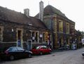
 A general view of the station. Even on a sunny day the station is plunged into darkness by the buildings that have sprung up around it.
 -
 The entrance to the station from Whiteladies Road.
 -
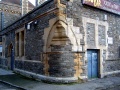
 One entrance to the station from the car park is through this rather wonderful gothic arch.
 -
 Looking across the footbridge.
 -
 Standing on the platform and looking back at the footbridge. The entrance on Whiteladies Road is in the top right corner, the dark tunnel being the road itself.
 -
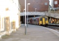 150261 stands in the station with a service to Temple Meads.
 -
 The platform shelter on Platform 1.
 -
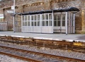
 The platform shelter on Platform 2.
 -
 The signs on the station echo a time when trains from all over the country would head here to give people a day out at Bristol Zoo.
 -
 The station building viewed from Platform 1.
 -
 Another view of the platform side of the station.
 -
 Viewed from the car park. The station building is now a bar.
 -
 One corner of the building.
 -
 Standing at the end of Platform 1 and looking towards St Johns Road.


