Crabtree Slip Wood: Difference between revisions
Jump to navigation
Jump to search
| Line 15: | Line 15: | ||
<gallery> | <gallery> | ||
Image:Crabtree Slip Wood2.jpg|Two more photos of the bridge. | Image:Crabtree Slip Wood2.jpg|Two more photos of the bridge. | ||
Image:Crabtree Slip Wood3.jpg| | Image:Crabtree Slip Wood3.jpg|It has been completely covered in graffiti since my 2005 photo. | ||
</gallery> | </gallery> | ||
[[Category:Bridges]] | [[Category:Bridges]] | ||
[[Category:BPR&P]] | [[Category:BPR&P]] | ||
[[Category:The Severn Beach Line]] | [[Category:The Severn Beach Line]] | ||
Revision as of 17:58, 23 February 2008
<googlemap lat="51.487049" lon="-2.655687"> 51.485559, -2.656267, Crabtree Slip Wood </googlemap>
To Bristol: River Trym
To Avonmouth: Horseshoe Curve
2005
30.8.05
-
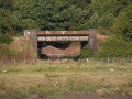 A bridge in Shirehampton, near the park and the golf course. Viewed from the opposite side of the River Avon.

2007
1.5.07
-
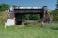 Two more photos of the bridge.
 -
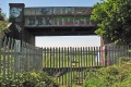 It has been completely covered in graffiti since my 2005 photo.

