Charfield Loops
<googlemap lat="51.632706" lon="-2.404718">
51.632403, -2.404702, Charfield Loops
</googlemap>To Yate: Wotton Road
To the North: Flour Mill
Track Plans
-
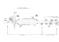 A track plan of Charfield Loops and surrounding area from 1988.

Gallery
3.9.06
-
 The southern end of the loops.
 -
 A footpath crosses the loops.
 -
 The view south from the middle of the footpath.
 -
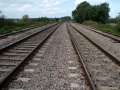 The view north.
 -
 A zoomed view north showing signal B455 protecting the exit from the loops.


