13 Arches Viaduct
<googlemap lat="51.476572" lon="-2.5599"> 51.474741, -2.560802, 13 Arches Viaduct </googlemap>
To Ashley Junction: Eastgate Road
To Kingswood Junction: Fishponds Road
1960s
Words and photos by Ian Tiley
-
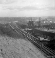 This one was taken from near Narroways Hill, whilst the line was still in use. © Ian Tiley
 -
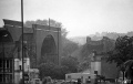
 This one was taken from the hill on the north/east side of Muller Road. This was taken a few days/weeks before it was demolished, the preparation work for demolition was under way, the ballast from the bridge is piled up on the embankments on both sides of the bridge. © Ian Tiley
 -
 Taken near Rousham Rd © Ian Tiley
 -
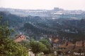 I think this one was taken from the hill on the south/west side of Muller Road. © Ian Tiley
 -
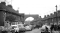
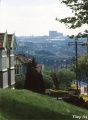 This one was taken from Muller Road, near the library. © Ian Tiley
 -
 This one was taken from Purdown and shows the clouds of dust just after the explosives were detonated. © Ian Tiley
 -
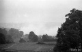
 This one was taken from the same place and shows what remained after the dust settled. © Ian Tiley
 -
 This one was taken on Cottrell Rd. © Ian Tiley
 -
 I think this was taken near the junction of Muller Rd and Stapleton Rd. The footbridge at Narroways Hill is just visible in the background. © Ian Tiley


2006
25.11.06
-
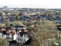 This is the exact same view as that in Ian's photo at the top of the page. © Alan Weeks
