Mina Road: Difference between revisions
Jump to navigation
Jump to search
No edit summary |
No edit summary |
||
| (2 intermediate revisions by the same user not shown) | |||
| Line 4: | Line 4: | ||
</googlemap> | </googlemap> | ||
</div> | </div> | ||
'''To Bristol''': [[Narroways | '''To Bristol''': [[Narroways Junction]]<br> | ||
'''To Avonmouth''': [[Horfield Brook]] | '''To Avonmouth''': [[Horfield Brook]] | ||
== | == 2003 == | ||
16.11.03 | |||
<gallery> | <gallery> | ||
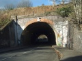
Image:Mina Road1.jpg| | Image:Mina Road1.jpg|A general view along '''Mina Road''' towards the tunnel under the railway lines. | ||
Image:Mina Road2.jpg| | Image:Mina Road2.jpg|A close up view of the tunnel. | ||
Image:Mina Road3.jpg| | Image:Mina Road3.jpg|A rather blurry view through the tunnel. | ||
Image:Mina Road4.jpg| | Image:Mina Road4.jpg|A view from above the tunnel looking along the railway towards [[Montpelier]]. The houses in the background are on [[Ashley Hill Junction|Ashley Hill]]. The signal in this picture is the one visible on that page. | ||
</gallery> | </gallery> | ||
== 10.6.06 | == 2006 == | ||
10.6.06 | |||
<gallery> | <gallery> | ||
Image:Mina Road5.jpg| | Image:Mina Road5.jpg|The approach to the tunnel has had a traffic calming scheme implemented. | ||
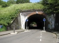
Image:Mina Road6.jpg| | Image:Mina Road6.jpg|The northern end of the tunnel. | ||
Image:Mina Road7.jpg| | Image:Mina Road7.jpg|The tunnel is lined with some very nice murals. | ||
</gallery> | </gallery> | ||
[[Category:Clifton Extension Railway]] | [[Category:Clifton Extension Railway]] | ||
Latest revision as of 19:12, 14 February 2008
<googlemap lat="51.475022" lon="-2.576036"> 51.472576, -2.576981, Mina Road </googlemap>
To Bristol: Narroways Junction
To Avonmouth: Horfield Brook
2003
16.11.03
-
 A general view along Mina Road towards the tunnel under the railway lines.
 -
 A close up view of the tunnel.
 -
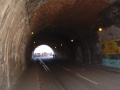 A rather blurry view through the tunnel.
 -
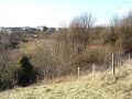 A view from above the tunnel looking along the railway towards Montpelier. The houses in the background are on Ashley Hill. The signal in this picture is the one visible on that page.


2006
10.6.06
-
 The approach to the tunnel has had a traffic calming scheme implemented.
 -
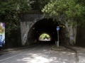 The northern end of the tunnel.
 -
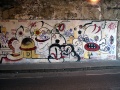 The tunnel is lined with some very nice murals.


