Pump House Siding: Difference between revisions
Jump to navigation
Jump to search
BristleGWR (talk | contribs) No edit summary |
|||
| (2 intermediate revisions by one other user not shown) | |||
| Line 2: | Line 2: | ||
<googlemap lat="51.568161" lon="-2.662725"> | <googlemap lat="51.568161" lon="-2.662725"> | ||
51.567267, -2.661095, Pump House Siding | 51.567267, -2.661095, Pump House Siding | ||
51.568274, -2.665215, [[Severn Tunnel]] | 51.568274, -2.665215, [[Severn Tunnel]] Pumping station | ||
</googlemap> | </googlemap> | ||
</div> | </div> | ||
'''To | '''To Severn Beach''': [[Green Lane Level Crossing]]<br> | ||
'''To | '''To Pilning''': [[New Passage Halt]]<br> | ||
'''To New Passage Pier''': [[Severn Tunnel Construction Line]] | |||
== History == | == History == | ||
Before electric pumps were installed, this pumping station was coal-fired and rail-connected. A siding ran from here to the [[Severn Beach]] - [[Pilning]] loop. | Before electric pumps were installed, this pumping station was coal-fired and rail-connected. A siding ran from here to the [[Severn Beach]] - [[Pilning]] loop.<br> | ||
This siding was original connected to the [[New Passage Pier]] line and ran to a shaft near the Pilning Portal of the [[Severn Tunnel]]. | |||
== Gallery == | == Gallery == | ||
<gallery> | <gallery> | ||
Latest revision as of 21:10, 9 April 2008
<googlemap lat="51.568161" lon="-2.662725"> 51.567267, -2.661095, Pump House Siding 51.568274, -2.665215, Severn Tunnel Pumping station </googlemap>
To Severn Beach: Green Lane Level Crossing
To Pilning: New Passage Halt
To New Passage Pier: Severn Tunnel Construction Line
History
Before electric pumps were installed, this pumping station was coal-fired and rail-connected. A siding ran from here to the Severn Beach - Pilning loop.
This siding was original connected to the New Passage Pier line and ran to a shaft near the Pilning Portal of the Severn Tunnel.
Gallery
-
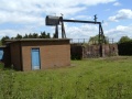 The pump on the Bristol side of the River Severn that helps prevent the Severn Tunnel flooding.
 -
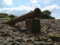 An outlet pipe on a nearby beach. This shingle beach was formed from debris brought up from the tunnel's workings.
 -
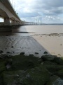 The Second Severn Crossing passes overhead right next to the alignment of the Severn Tunnel.


