Clifton Bridge: Difference between revisions
New page: <div style="float:right"> <googlemap lat="51.448872" lon="-2.625132"> 51.447013, -2.625797, </googlemap> </div> '''To Parson Street Junction''': Access Bridge<br> '''To Portishead'''... |
|||
| Line 18: | Line 18: | ||
Image:Clifton Bridge5.jpg|The view towards [[Portishead]]. All these photos show the bay that was at the north end of the station. This was used for goods traffic. ''© [[:Category:Gerald Peacock|Gerald Peacock]]'' | Image:Clifton Bridge5.jpg|The view towards [[Portishead]]. All these photos show the bay that was at the north end of the station. This was used for goods traffic. ''© [[:Category:Gerald Peacock|Gerald Peacock]]'' | ||
</gallery> | </gallery> | ||
== | == 2004 == | ||
7.3.04 | |||
<gallery> | <gallery> | ||
Image:Clifton Bridge6.jpg|The station footbridge survives. | Image:Clifton Bridge6.jpg|The station footbridge survives. | ||
Revision as of 11:15, 21 February 2008
<googlemap lat="51.448872" lon="-2.625132"> 51.447013, -2.625797, </googlemap>
To Parson Street Junction: Access Bridge
To Portishead: Rownham Hill
History
Opened on 18th April 1867 as a single platform. A crossing loop and second platform were brought into use on 15th September 1880 and the section of line between the station and Parson Street Junction was doubled on 2nd December 1883. The station was downgraded to a halt and became unstaffed on 29th October 1962. It closed to passengers on 7th September 1964 and goods on 5th July 1965. Between March 1891 and 1910 the station was called Rownham to avoid confusion with Clifton and Clifton Down.
The original Clifton Bridge Signal Box closed on 25th August 1907. It was replaced by a larger structure which closed on 4th November 1966.
1980s
-
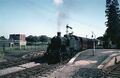 82040 about to leave Clifton Bridge with a service for Portishead. Ashton Swing Bridge, complete with road and cabin on the top deck, is visible in the background. © Gerald Peacock
 -
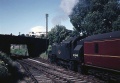 The same train departs the station and passes under Rownham Hill bridge. © Gerald Peacock
 -
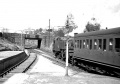
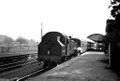 82007 at the station with a service for Portishead. © Gerald Peacock
 -
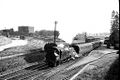 Clifton Bridge Station with Ashton Swing Bridge in the background. © Gerald Peacock
 -
 The view towards Portishead. All these photos show the bay that was at the north end of the station. This was used for goods traffic. © Gerald Peacock


2004
7.3.04
-
 The station footbridge survives.
 -
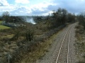
 The view south from the footbridge.
 -
 The view panned slightly to the right. The buildings in the background belonged to the engineering depot at Ashton Meadows Sidings. The strip of land between the allotments and the railway boundary fence was the site of Ashton Gate Carriage Sidings.
 -
 The view north from the footbridge showing the remains of the station. The headquarters of the mounted division of the Avon and Somerset Constabulary occupy the spot where the main station building stood.
 -
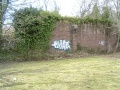 This huge wall once held up a large arc-roofed canopy.
 -
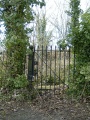 The up platform entrance gate was still in place.


