Royate Hill Viaduct: Difference between revisions
Jump to navigation
Jump to search
New page: <div style="float:right"> <googlemap lat="51.472348" lon="-2.551403"> 51.471226, -2.551811, Royate Hill Viaduct </googlemap> </div> '''To Ashley Junction''': Greenbank View<br> '''To K... |
No edit summary |
||
| Line 1: | Line 1: | ||
'''To Ashley Junction''': [[Greenbank View]]<br> | '''To Ashley Junction''': [[Greenbank View]]<br> | ||
'''To Kingswood Junction''': [[Wainbrook Drive]]<br> | '''To Kingswood Junction''': [[Wainbrook Drive]]<br> | ||
Latest revision as of 18:29, 31 March 2026
To Ashley Junction: Greenbank View
To Kingswood Junction: Wainbrook Drive
Gallery
20.6.06
-
 A panoramic view of the viaduct created from three photos stitched together. Kingswood Junction is to the left, Ashley Hill Junction to the right.
 -
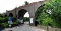
 The other side of the viaduct.
 -
 In the 1990s, the site of Royate Hill was earmarked for development. Luckily the then Avon County Council stepped in and, after compulsory purchasing the land from the developers, turned the area into a nature reserve.
 -
 A derelict permanent way hut survives on top of the viaduct at the Greenbank View end.


