Robins Wood
Jump to navigation
Jump to search
<googlemap lat="51.545388" lon="-2.461989"> 51.545107, -2.462118, Robins Wood </googlemap>
To Yate: Nibley Lane
To Thornbury: Iron Acton
12.12.04
-
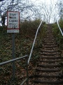 Approaching the crossing from a footpath that starts behind the Church of St James in Iron Acton.
 -
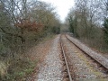
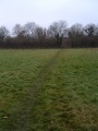
 The view along the track in the direction of Yate.
 -
 The view in the Thornbury direction. Just ahead of where I'm standing are some railings. This is spot where a bridge stands.
 -
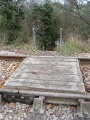 The crossing itself. It's on quite a high embankment.
 -
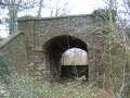 A few steps away from the footpath is the bridge seen in the previous photo. It seems odd to take a footpath across the railway line when there is this (unused) bridge just a few feet away.
 -
 A longshot from the fields at Tubb's Bottom showing the railway embankment in the distance.


