Yate South Junction
Jump to navigation
Jump to search
<googlemap lat="51.540517" lon="-2.43433"> 51.536823, -2.434958, Yate South Junction </googlemap>
To Bristol via Parkway: Westerleigh Common
To Bristol via Mangotsfield: Nibley Lane
To the North: Yate
Track Plans
-
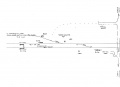 A track plan of Yate South and surrounding area from 1988.

Gallery
-
 The view south in 1972 with a Peak storming past. The ex-Midland railway line drops down at the right of the picture. © Clive Moore
 -
 The view north with Yate Station in the distance. Another Peak trundles through with a cross-country service. © Clive Moore

