Iron Acton: Difference between revisions
Jump to navigation
Jump to search
No edit summary |
No edit summary |
||
| Line 1: | Line 1: | ||
<div style="float:right"> | |||
<googlemap lat="51.547536" lon="-2.468641"> | |||
51.547416, -2.468748, Iron Acton | |||
</googlemap> | |||
</div> | |||
'''To Yate''': [[Robins Wood]] | '''To Yate''': [[Robins Wood]] | ||
<br>'''To Thornbury''': [[Bristol Road]] | <br>'''To Thornbury''': [[Bristol Road]] | ||
<br>'''To Frampton Cotterell''': [[Frampton Cotterell]] | <br>'''To Frampton Cotterell''': [[Frampton Cotterell]] | ||
== History == | == History == | ||
Opened on 2nd September [[1872]]. Closed on 19th June [[1944]] except for a coal depot which closed on 10th June [[1963]]. | Opened on 2nd September [[1872]]. Closed on 19th June [[1944]] except for a coal depot which closed on 10th June [[1963]]. | ||
== 1960s == | == 1960s == | ||
<gallery> | <gallery> | ||
| Line 14: | Line 15: | ||
Image:Iron Acton20.jpg|Having dropped off one wagon, the loco recouples to its train. | Image:Iron Acton20.jpg|Having dropped off one wagon, the loco recouples to its train. | ||
</gallery> | </gallery> | ||
== 2004 == | == 2004 == | ||
<gallery> | <gallery> | ||
Revision as of 18:40, 3 November 2007
<googlemap lat="51.547536" lon="-2.468641"> 51.547416, -2.468748, Iron Acton </googlemap>
To Yate: Robins Wood
To Thornbury: Bristol Road
To Frampton Cotterell: Frampton Cotterell
History
Opened on 2nd September 1872. Closed on 19th June 1944 except for a coal depot which closed on 10th June 1963.
1960s
-
-
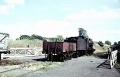
 The loco backs onto a siding. This was the stub of a branch that led to iron mines at Frampton Cotterell. The loading gauge seems to be very small in this photo. There's no way the loco will fit under it.
 -
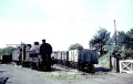
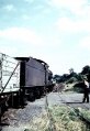 Having dropped off one wagon, the loco recouples to its train.


2004
-
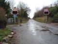
 Standing on Station Road and looking in the direction of Yate.
 -
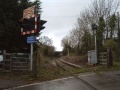
 The view of the crossing. The crossing keepers house can just be seen to the right.
 -
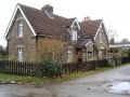 The crossing keeper's house is now a private dwelling.
 -
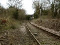
 The view across the crossing in the other direction.
 -
 The line disappears around a bend as it heads off towards Thornbury. The bridge in the distance is on Bristol Road. The line to the iron mine left the Thornbury branch here and swung around to the left of this photo.
 -
 Stretching the digital zoom to the limit in order to get a close up shot of the Bristol Road bridge.


